
2. Input files
2.1 WindSim files
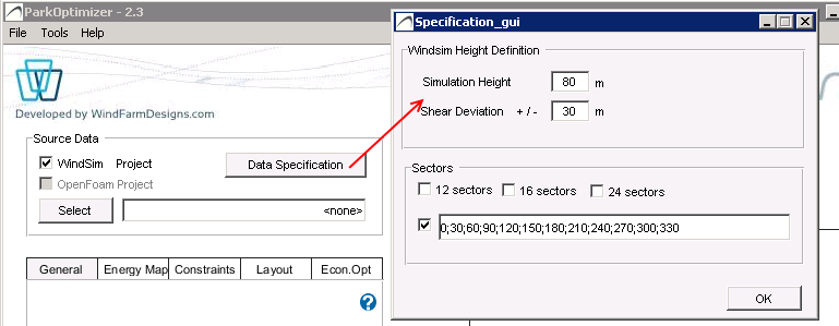
WindSim simulations of windspeed and turbulence must be generated at heights as specified in the GUI, and for 12 sectors of wind direction from 0 to 330 degrees. Press the Height Definition button to modify the simulation heights. For shear calculation, the +/- distance from simulation height must correspond to simulation results from WindSim.
It is also possible to choose 12, 16 and 24 sectors, or a user-defined set of sectors for WindSim input data specification. Note that only 12 sectors are eligible for the layout optimization functionality.
The following files are required, where sss denotes the 12 sectors:
.\windfield\speed_2d_sss_hhhh_nt0.scl— horizontal wind speed (hhhh = Simulation Height and the Height ± Shear Deviation)..\windfield\wcrt_sss_hhhh_nt0.scl— vertical wind speed (hhhh = Simulation Height)..\windfield\ti_sss_hhhh_nt0.scl— turbulence intensity (hhhh = Simulation Height)..\dtm\view_inclination.scl— terrain inclination.- Wind Resource
.wrgfile at the Simulation Height. Normally located in.\Layout\Report.
Note that if a measurement tws file is defined in Turbulence Setup of the Constraints Map tab, then a turbulence intensity file at the measurement height is required.
2.2 Other files
Turbine specification file (.pws), defining the power-curve PC, thrust-coefficient Ct functions, and noise curves. ParkOptimizer version > 2.3 can read both the old .pws format (no noise data) and the new format (with noise data).
Wind measurement file (.tws), for optional turbulence and extreme wind in the IEC Constraints calculation.